Neighborhood and Subdivision Boundaries
This dataset is only available in institutional licenses
Overview
Neighborhood and Residential Subdivision Boundaries are the pinnacle of hyperlocal search. They cover small geographic areas, and those areas are comprised of social communities with their own identities. The names and boundaries are familiar to local residents. There are 4 levels to this dataset:
Level 1 – Macro-Neighborhoods
This level is the largest neighborhood type by size and usually depict regions, major sections of a city, or large master planned communities
Level 2 – Neighborhoods
This level represents the common definition of a city-level neighborhood, typically comprised of a colloquial grouping of streets and commonly referenced by local residents.
Level 3 – Sub-Neighborhoods
This level typically represents smaller named areas with an existing level 2 neighborhood. These are usually found in the core of the city and are often business, financial, entertainment, arts, cultural, or historic districts.
Level 4 – Residential Subdivisions
This level is comprised primarily of boundaries for subdivisions, condominiums, townhome communities, apartment complexes, retirement communities, mobile home parks, and other residential housing tracts
| Data Information | Value |
|---|---|
| Refresh Cadence | Monthly |
| Historical Coverage | NA |
| Geographic Coverage | US |
| Observation Level | Neighborhood/Subdivision |
Schema
This dataset contains 73 different attributes. To view the schema, please refer to the dataset's dataset listing.
Key Concepts ↗️
Joining Datasets
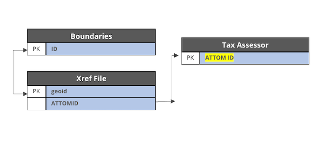
To join the boundary files to the other ATTOM datasets, you'll want to download the ATTOM XREF Files. These files include an ATTOM ID associated with a GEOID and GEOTYPE, which can be used to join to the other files.

Updated 7 months ago